All posts by Gary or Joyce

First Day

The 6 hour time difference messed up our sleep last night.  Awake several times after retiring about 8:30 PM.  Finally did some email and logging geocaches at 4 AM.   Back to sleep for a while.  Finally “up” around 7:30.

We visited with Aunt Janet for most of the morning while having coffee and breakfast. After quick showers (enhanced by small hot water tank) we decided to take a short ride to get a geocache, scout Lahaina and get some lunch.  After checking out a few places menus, we opted for a burger at the Lahaina Fish Co.  Watched out to the water from their deck.

Next stop the grocery store for meals the next few days.


Dallas and Holding!

Up at 4 AM this morning to catch the shuttle to the Philly airport.  Quick ride and easy check in.  Passed without trouble through Security.  On time departure and early arrival in Dallas.

Originally supposed to depart at 10:50 AM  local time.  Due to a maintenance problem they took the plan we were supposed to board out of service.  They had to find another plane–one inbound from Frankfurt

Now we have a 2 PM departure!


Summary of Route 66 Adventure

Well, we’ve returned and recovered from this adventure.  People keep asking what we like best on the trip.  Well, there were so many things it is hard to decide, but after some thought, below you will find those things we thought highly of or discovered on our trip to be really interesting.

Top Ten Favorites

10. Lou Mitchell’s Restaurant (Chicago, IL) – walked here from Grant Park and had milkshakes to start off the Route 66 experience.

9. People we met – Geoff Ladd gave us a tour of an old restaurant (Lincoln, IL); Louise of Munger Moss Motel (Lebanon, MO); Gary and Leana of Gay Parita Restored Gas Station (Paris Junction, MO), a lifeguard who gave us a tour of a period building, now the bathhouse with a turret (Sayer, OK)

8. Standing on the Corner in Winslow, AZ

7. Painted Desert (Petrified Forest Nat’l Park, AZ) and Mojave Desert (Amboy, CA) (we mentioned the hike to find 20 geocaches in about 113 degrees)

6. Chain of Rocks Bridge crossing the Mississippi River (north of St Louis, MO) – we walked across since the bridge is closed to vehicular traffic

5. Iconic wayside attractions: Totem Pole Park (Foyil, OK), sleeping in a tee-pee at the Wigwam Village (Holbrook, AZ); walldog billboard/signs (Pontiac, IL); Cadillac Ranch (Amarillo, TX); Burma Shave signs (Towanda, IL & Seligman AZ); world’s largest rocking chair (Fanning, MO); Midway Café (Adrian, TX)

4. Restored gas stations: Dwight, IL; Odell, IL; Spencer, MO; Baxter Springs, KS; Chandler, OK; Afton, OK; McLean, TX; Vega, TX and more

3. Driving on the Sidewalk Highway (Miami, OK) (one lane wide to make the construction funds go farther; cars had to drive with two tires on the pavement and two on the unpaved shoulder)

2. Seeing the real locations which inspired the movie ‘Cars.’ The town the interstate passed aka Radiator Springs (Seligman, AZ). Inspiration for Sally, the owner of the Rock Café (Stroud, OK). Inspiration for Ramone’s was a restored gas station (Shamrock, TX).

1. Arriving at the Santa Monica Pier for the end of the historic Route 66

Worst or Un-favorites

Mules walking the streets in Oatman, AZ leaving calling cards on the boardwalk

113 degrees in the Mojave Dessert and we still hiked for 2-3 miles

Traffic in California

Other “bests” on the trip!

Best Day: In Oklahoma – Saw totem poles, a whale, bridges, gas stations, old hotels, round barns, ate at Sally’s Rock Café, drove on a section of brick road, drank Route 66 pop and ended with a Priceline hotel that was actually short term apartments for FAA trainees in Tulsa complete with our own washer and drier.

Highest Elevation: Hiked to Cecret Lake (Alta, UT) at 9,800 feet

Hottest Day: 113 degrees in the Mojave Desert

Biggest Relief: Finding the strange sound the Murano was making was an easily repaired wheel bearing (Rollo, MO)

Worst Event: Stolen credit card number with 5 charges that Discover will deal with

Best Photo Ops: Tie between The Grand Canyon and Zions National Parks – both awesome, but quite different

Best BBQ: Tie – Elbow Inn Bar & BBQ (Devil’s Elbow, MO) and The Rib Company (Twentynine Palms, CA)

Most Unexpected Cool Event: Viewing Comic Con attendee costumes on the way to hear Utah Symphony “Video Games Live” (Salt Lake City, UT)

Best Science/Geology: Joshua Tree Nat’l Park including huge boulder fields, meeting of the Mojave and Colorado deserts, Joshua Trees, chance to see the moon in a 14” telescope

Best Milkshake (of 3): Bear Lake, ID – Raspberry and Banana with fresh fruit
Desert Rat Day!!

Today we knew we’d be crossing the Mohave Desert once we left Kingman, AZ.  And what a day it was!  As we expected hot weather today, we decided to leave earlier than most of the other days.  So, we were up, had coffee & breakfast, packed the car and were on our way at 7:30 AM.

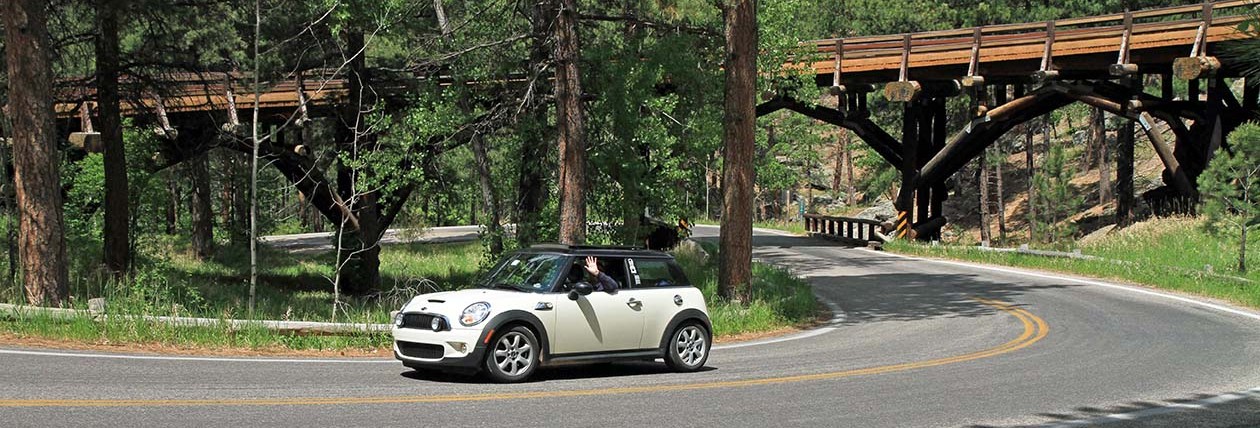
On the way out of Kingman, we took some time to photograph some of the buildings and signs.  Then we found our way to historic Route 66 known as Oatman Road west of Kingman.  Oatman Road continued west over the Black Mountains.  Along the way, the variety of cacti changed from the east side to the west side.  And the road, well, it was a Mini road!  We stopped on the way up the mountain at a local establishment called Cool Springs Cabins where we met and talked with the proprietor while we obtained a couple of Pepsi’s and a post card before continuing on our way.  We got some good advice and learned that the trip over to Oatman was 8 miles and included 122 curves/switchbacks over Sitgraves Pass.

20140829_092056

Top speed–20 mph with some places marked 15 and a few at 10 mph.  A great ride!

Oatman, AZ is famous for its free roaming burros.  We saw 8 or 10 and photographed a few.  Otherwise, the town is mostly a tourist mecca.  Moving on to, the next place on our list was Needles, CA.  We photographed some saw tooth shaped mountains and the “Welcome to California” sign as we crossed the Colorado River.

20140829_103211

There was a noticeable difference in the arid climate between Oatman and Needles–much drier and the vegetation changed again.  Different cacti!

In Needles, we took a few photos and took an alternative route through town on a second pass following the instructions from our maps.  If doing it again, I’d say these few blocks don’t add any value to the trip.  On the way out of town, we had some trouble finding the route and took CA-95 N heading toward Nevada.  We figured it out after 8 miles and turned around to get back on the route.  When we got back to the correct turnoff, it was marked going south, but there was no sign on the north bound side.

This put us in the direction of Chamblis and Amboy.  This was where Joyce had staked out a geocaching expedition in the Mohave Desert.  It’s a special kind of cache called geoart.  From the map, there were a lot of geocaches 0.1 mile apart that formed the US highway shield, two “6” figures and the letters RT at the top.  Just like the signs.  There was no thought of doing all of these, but we did about 24 in about 2-1/2 hours.  Walking around the Mohave Desert between 1:30 and 4:00 PM was a hot experience!  We had plenty of water, food in case we got lost, walking sticks and a GPSr.  We found all but one on the circular part of one “6” but didn’t want to continue  to finish the 6 because of time in the sun and heat.

Gary in the desert!

20140829_144515

The Mohave Desert….


20140829_135454

Oh, yeah, speaking of heat, here’s how the day went:

9:30 AM       90 degrees
11:30 AM  101 degrees
12:00 N      102 degrees
12:30 PM  104 degrees
12:40 PM  105 degrees
12:56 PM  107 degrees
01:00 PM 108 degrees
01:10 PM 106 degrees
04:45 PM 113 degrees
05:30 PM 107 degrees

We had 5-60 air conditioning until about 12:30 when we turned the A/C on for the rest of the day.

While walking around in the Mohave, we lost site of the car for most of the time.  It would be easy to get totally lost within about 0.25 miles.  On the way back after finding the last cache, I kept thinking what if we can’t find the car (failed to mark it’s location on the GPSr when we started out) or it went missing.  Fortunately, the first cache we found was within sight of the car.

I also found that I could “smell” the heat because the air was different and the arid climate changed the ability to smell.  It was probably 113 to 114 during our caching experience.  Saw a few lizards, a jackrabbit and very little else.  The vegetation was also limited.  We had a good time and drank all the water doing this.

After the cache, we had a cold beer in the car while the A/C ran to cool off the car.  Plus a few crackers for sustenance to get us to Roy’s Café in Amboy, CA.  We found a cache at Roy’s and had a Route 66 Rootbeer each before continuing on our way to Twentynine Palms, CA where planned to spend a couple of nights and see Joshua Tree National Park before returning to the historic Route 66 drive.

Arrived in Twentynine Palms about 5:30 and checked in to the Best Western, unloaded the car and sat back to soak up some cool while watching the news, Wheel and Jeopardy.  Maybe the pool will be next!

No pictures of the desert rats though!


Santa Fe to Albuquerque (Thursday)

Yes, it’s only 60 miles from Santa Fe to Albuquerque, but it took us nearly all day to get there.  We left at SF 8 AM and arrived ABQ at 3:30-ish!

But there was a side trip a couple a few miles out of SF called the La Bajada.  Of course, it had a cache.  Only thing is we had to walk up hill to get it.  It was located on a really old section of the historic route 66 that is today only passable via high clearance 4-wheel drive vehicles.  Lots of curves, big rocks and wash outs.  However, we did see two such vehicles making the trek during hour hike up to get the cache which took us about an hour to get to the top.  It was 1.67 miles.  Only 37 minutes to return to the car.  Gravity works better going down!

As we neared ABQ Joyce wanted to see the Petraglyph National Monument.  So, we stopped and spent about an hour walking on the Boca Negra trail which, you guessed it, was mostly up.  We saw quite a few of the petraglypys on the rocks for hundreds to thousands of years old made by the ancient Pueblo people who inhabited the Rio Grande river valley.

Arriving at our hotel, another Best Western, we decided the weather might be better tonight  for taking the Sandia Peak Tram up to the top in hopes of getting great pictures and a nice dinner.   We hurried out of the hotel and up the road to get there in time to take the 5 PM tram to the top for our dinner reservations at the High Finance Restaurant.  Yep, high finance alright!  As usual we shared an entrée and both were too full for dessert.

We stayed on top until just after sunset taking the tram back down.

Although there was a geocache located in the parking lot, we didn’t find it.  Then followed the Garmin nuvi back to the hotel by some different route than we got there.

Tomorrow, depending on the weather is ABQ day.

Route 66 Photos (Finally)

Finally, some photos from the first two days of the Route 66 Adventure!  These are all from my phone camera, but most photos are on the “big camera” and take more time to get from camera to web!  These will have to do for now.


Lunch at Lou Mitchells's Restaurant--the traditional starting place for a Route 66 Journey.
Lunch at Lou Mitchells’s Restaurant–the traditional starting place for a Route 66 Journey.
Joyce enjoys her Black Cow (rootbeer float) at Lou Mitchell's
Joyce enjoys her Black Cow (rootbeer float) at Lou Mitchell’s
Castle Car Wash (south of Chicago)

20140811_151007

Gemini Giant (Wilmington, IL)
Polk-a-Dot Drive In (Braidwood, IL)
Riveria Diner and Two Cell Jail (Gardner, IL)
Mobil Station (Odell, IL)
Millers Gas Station (Odell, IL)

20140811_200447