Category Archives: Route 66

Finally, Grand Canyon National Park!!!

We started the day in Holbrook, AZ by taking some photographs about sunrise of the few signs and structures of interest in town.   Since the Wigwam had no coffee either in rooms or lobby, we also stopped at Joe & Aggies Café for coffee to go.   Then back to the Wigwam to finish getting ready for the day and a few additional photos.

We departed Holbrook about 8 AM–early for us!  We passed through Joseph City, AZ and stopped at the Jackrabbit Trading Post for a geocache and a few pictures.  Once again we saw a lot of BNSF trains between Jackrabbit and Winslow, AZ (yes, the famous Winslow in song). In Winslow we stopped to take a few photos of Gary and Joyce with the statue that is a requisite stop on Route 66 trips.

Good night from the Grand Canyon National Park Area.

Oh, yeah, maybe Joyce is right and we haven’t been here before.  Of course the decision still depends on reaching the North Rim sometime in the next couple of weeks.

We also stopped for a geocache at the famous La Pasada Hotel in Winslow.  It is the last of the hotels that were associated with the railroad stops and AMTRAK still stops there today.  It was a very beautiful hotel.

It was about 11:30 AM (MST) when we arrived in Winslow.  After our caching and photography opportunities, we continued on our way to Cameron, AZ where we had decided to spend two nights.  We arrived at 12:30 PM (MST) today and were able to check in to the famous Cameron Trading Post and Motel.  Have a nice room overlooking the Little Colorado River and some nice red rocks.

After checking in, we decided to make our first foray into the Grand Canyon National Park. It was 25 miles from Cameron to the East entrance to the park.  We drove the additional 30 miles to along the South Rim to the main visitor area.  We stopped at 5 or 6 places to take some beautiful photos.  We arrived at the main visitor center around 5 PM.  Took a few photos, but the sun was fading behind clouds and there was some lightening and thunder in the distance.  We left!  Figuring that we’d be back tomorrow for more photo ops.

Somewhere along the GCNP visit today, Joyce learned that the Grand Canyon is bigger than the state of Delaware.  Perhaps shocking, but really, no surprise given the smallness of DE!

It took over an hour to return to Cameron for our hotel.  About 60 miles.  It included a brief stop to photograph two elk fighting for dominance and a geocache find in a primitive camping area just off the main road.

Here are a couple of photos from today.  Unfortunately, the other 4 couldn’t be uploaded due to slow internet connection.

If you think you internet access is slow, you should try these remote areas of the country.  It reminds me what a vast country we have to provide infrastructure for and the difficulties those of us with faster connections have when we are without!

20140825_150125


20140825_165101

We drove about 250 miles today including the 120 from Cameron to GCNP and back.  We also decided on an unscheduled side trip to see the Meteor Crater.  When we got there we discovered it wasn’t part of the NP system and cost $16 per person to look at a big hole in the ground.  We decided against this activity and kept on drivin’ on.

After getting back to the hotel, we found a nearby cache and took a few photos of the last remnants of the sunset.  Dinner was from our supplies and included cheese & crackers, peanut butter crackers, apples and, of course, red wine.

We plan to arise early tomorrow and make our way before sunrise to the visitor center and take the park provided shuttles to the areas west of the visitor center.  The day is basically unstructured otherwise.
 

Painted Desert

No photos today–sorry, but there’s no easily accessible Internet here in Holbrook, AZ!

We left Gallup, NM this morning about 8:30 AM MDT. We took a few photos on the way to Holbrook, AZ where we had a reservation at the Wigwam Motel–one of the last still in operation on 66.

We found the first geocache of the 6say at the AZ Welcome Center around 9:30 AM MST.  Just like that we moved all our timepieces an hour earlier.  Time to adjust again.

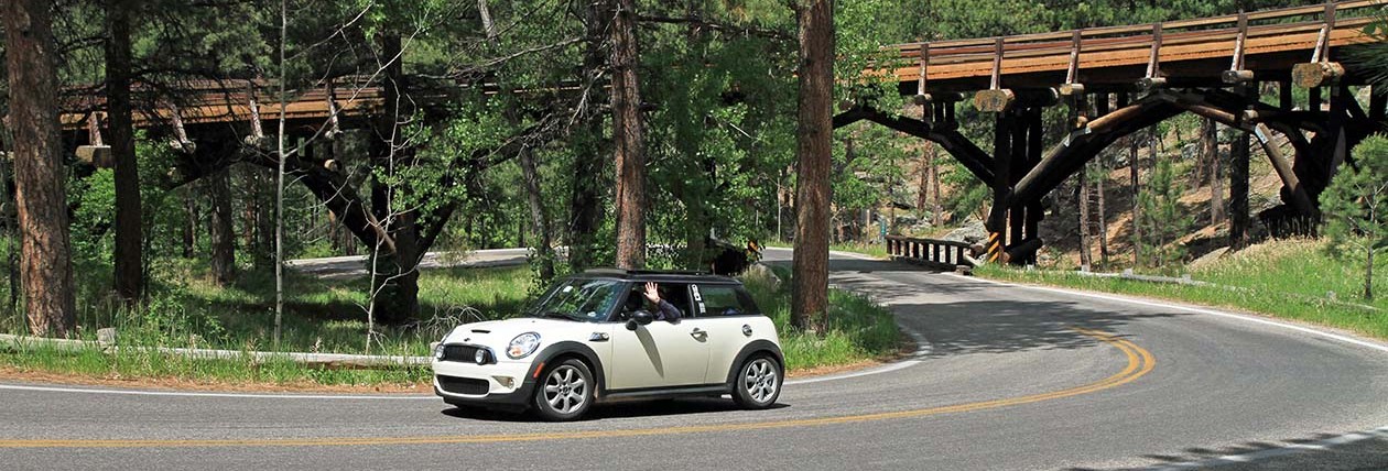
We took a couple of alternate routings today.  The first was an early alignment  at the Pine Springs exit off of I-40W.  Here we drove about 4-1/2 miles on a dirt road that was in pretty good shape.  Along the way we got to see and traverse the Querino Canyon high bridge built in 1929.  It was interesting to photograph.  Also at this site were the remains of a burned down trading post.

NOTE: For a good portion of AZ the interstate took over the 66 right of way so there is very little of the old alignment still available-no choice but to take the interstate!

The next attempt to see the old alignment of 66 was at the Pinta Road exit.   Here we took a one lane dirt access road that took us to a closed section of the old highway.  Unfortunately the information we had was out of date.  There was a gate chained closed and a No Trespassing sign on it.  Turned around and continued our journey to the Painted Desert and Petrified Forest National Park.   We arrives there around 11:30 and stopped in at the visitor center.  After we got our map we were ready to go.

Made use of our Senior Pass to gain admission without cost.  Then we were off to many stops to take photos, a few walks (you couldn’t really call them hikes) and to discover 5 geocaches.  Ate a packed lunch about 1:30.

We departed the park around 4:45 and made it to Holbrook around 5:30 MST where we checked in at the Wigwam Motel for a 1950s/60s experience.

Ate steak again….  split a filet at the Butterfield Stage Co  Steak house and drank a local beer that was just okay.   The restaurant was started as an overland stage company carrying US Mail.  They were the only ones going through Indian territory and when people wanted to go there they had to improve their service to carry passengers.

Agter dinner we tried to take some sign pbotos and the bought some beer at a drive up liquor store–on a Sunday night no less!

Okay, we’re esconced in our teepee for the night.  On to the Grand Canyon tomorrow!

Gallup,NM

We finally left ABQ around 10:30 this morning after chasing balloons and having a later breakfast.  We had to back track a little on the way out of town because we misread the instructions from the 8-map publications from about 6 years ago.  But that was okay, we got to see a couple of things we hadn’t seen. Once we were on our way, the traffic was pretty heavy for a Saturday until we had gone about 15 or 20 miles SW of ABQ. Urbanization occurs everwhere…  Then we were back into more open road. Places on the map today were: Laguna Indian Pueblo (Reservation) Correo Laguna Budville San Fidel Grants Prewett Gallup At Correo we took an alternate alignment for the historic Route 66.  This was a really great drive on a mostly dirt/gravel road although there were a few miles that had old pavement still showing.  We were only able to drive about 12 mph while avoiding potholes, washboard road surfaces and 3 or 4 other cars!  This section was about 10 or 12 miles long.

Original Alignment of Route 66 in New Mexico.  This is the best section!
Original Alignment of Route 66 in New Mexico. This is the best section!

After we got back on better pavement, we had to go around a mesa and a formation called Owl Rock.  Looked just like an owl, too!  This was between Budville and Laguna.

Red Rock Formation Near Laguna Pueblo

San Fidel was a ghost town with three or four old abandoned buildings.  But it had a new post office!  We found a geocache here that was protected by a RT 66 sign. We saw a lot of freight trains today.  They seemed to be about every 20 or 30 minutes.  It was a big surprise to see the number of FedEx and UPS trucks on the open cars! Between Prewett and Gallup we were finally seeing the red rock formations the southwest is known for.  Also saw some lava fields in close proximity to the red rock formations.  Pretty interesting. A few miles out of Gallup we stopped to see what was in the Red Rock Park.  Mostly it seemed to be a place for limited camping and rodeo activity.  Quiet today, but surely rodeo season is coming soon.  There was an interesting old post office that we photographed and a rock formation called Church Rock.  Then we continued on to Gallup. After checking into our hotel for the night the sun was still pretty high in the west.  So, we took that time to photograph the motel signs in warm sunlight followed by dinner.  We ate at a 3 diamond AAA rated restaurant called Earl’s since 1947.  On the menu they had a selection of half dinners for the smaller appetites.  We both selected fried chicken.  This was one of the few places that served real vegetables with the meal.  Had a choice, too!  Joyce got salad, green beans and mashed potatoes  while Gary selected pinto beans, mashed potatoes and vegetable soup.  The food was pretty good and it wasn’t a chain restaurant.  However, the local population of artisans made the rounds trying to sell handmade jewelry and other treasures.  We said no thank you at least 20 times! Following dinner Gary wanted to take a drive on a road he had seen on the GPS map while photographing the motels signs.  It was called Superman Canyon Road. Hopefully there are some nice pictures of red rock and a sunset. Before returning to the hotel we made one more pass to photograph the neon signs lit up at dusk.  Harder to do than you might think.

Oh What Beautiful Mornin’

While having our morning coffee in the room this morning,  I happened to notice some hot air balloons reflected in the mirror. I wanted to photograph them, so I hurried through my shower and decided to get in the car and chase them down.

Joyce at first more interested in breakfast, but on second thought decided to join me on the chase.  They had started west of town and were heading east.  So we hopped on I-40E and zoomed over to I-25N and got off a couple of exits later.  After driving around a shopping center for about 5 minutes we came upon one balloon landing in an open field and were able to get quite a few photographs.  We also got an opportunity to talk with the balloonists and their passengers.

What a start to the day !

20140823_080630

Old Town Albuquerque

Well we spent the rainy morning doing laundry, downloading photos from Joyce’s camera and making plans for tomorrow’s trip to Gallup, NM.

To satisfy midday hunger we decided to make our way to Old Town.  Found one cache on the stroll around the square.  Then located La Hacienda where we had a nice lunch of enchiladas.

20140822_140257

Can you tell which belongs to Gary or Joyce?

20140822_14180020140822_141810

Then we tried to unsuccessfully locate another two caches in a nearby park.  We used most of the afternoon to do some grocery shopping at Target to beef up our supplies for the next few days.  Since I had failed to pack long sleeve shirts, we also found an REI here in ABQ where we were able to find an ExOfficio long sleeve bugs away shirt for the cooler upcoming nights in the high altitudes of Arizona.

Dinner in our hotel!  A little TV and then nighty night for our trip to Gallup, NM tomorrow.


Albuquerque Friday Morning

We awoke to a cloudy, rainy morning!  Looks like we made the right decision to go to Sandia Peak yesterday.  Will need to find a few indoor activities until it clears up this afternoon.

Here are a couple of photos from yesterdays activities.

A beautiful cactus from the La Bajada hike

20140821_095901


A petroglyph from the Petroglyph National Monument of unknown meaning


20140821_143754

Santa Fe to Albuquerque (Thursday)

Yes, it’s only 60 miles from Santa Fe to Albuquerque, but it took us nearly all day to get there.  We left at SF 8 AM and arrived ABQ at 3:30-ish!

But there was a side trip a couple a few miles out of SF called the La Bajada.  Of course, it had a cache.  Only thing is we had to walk up hill to get it.  It was located on a really old section of the historic route 66 that is today only passable via high clearance 4-wheel drive vehicles.  Lots of curves, big rocks and wash outs.  However, we did see two such vehicles making the trek during hour hike up to get the cache which took us about an hour to get to the top.  It was 1.67 miles.  Only 37 minutes to return to the car.  Gravity works better going down!

As we neared ABQ Joyce wanted to see the Petraglyph National Monument.  So, we stopped and spent about an hour walking on the Boca Negra trail which, you guessed it, was mostly up.  We saw quite a few of the petraglypys on the rocks for hundreds to thousands of years old made by the ancient Pueblo people who inhabited the Rio Grande river valley.

Arriving at our hotel, another Best Western, we decided the weather might be better tonight  for taking the Sandia Peak Tram up to the top in hopes of getting great pictures and a nice dinner.   We hurried out of the hotel and up the road to get there in time to take the 5 PM tram to the top for our dinner reservations at the High Finance Restaurant.  Yep, high finance alright!  As usual we shared an entrée and both were too full for dessert.

We stayed on top until just after sunset taking the tram back down.

Although there was a geocache located in the parking lot, we didn’t find it.  Then followed the Garmin nuvi back to the hotel by some different route than we got there.

Tomorrow, depending on the weather is ABQ day.

Santa Fe Day

We had a leisurely morning.  Since there was no coffee in the room (4* hotel downtown) we walked about 4 blocks ti a small Italian cafe where we had great coffee and breakfast.

We spent the morning sightseeing by foot in downtown Santa Fe.  We saw the “miraculous spiral staircase” at the Loretto Chapel and the lobby of the La Fonda hotel where we obtained another geocache.  This was followed by a visit to the New Mexico State Capitol where we also found another geocache.

20140820_122505

For lunch we went to the Travel Bug Cafe where we “discovered” the travel bug on the Murano and got another geocache find.

In the afternoon we visited the Georgia O’Keeffe museum and found two more geocaches.

20140820_155426

This followed by a beer in the hotel bar/patio and dinner at Mangiamo Pronto Cafe Italiano.

On the way back to the hotel we stopped in the central square for some live music.   Tomorrow we depart for Albuquerque.

Tucumcari to Santa Fe!

We got up shortly after sunrise from our lodging at the Roadrunner Lodge in Tucumcari, dressed and started walking with camera in hand to photograph some of the signs, motels and other buildings in the early morning sunlight.  This without the first cup of coffee!

After we returned we got coffee at the motel lobby and got in the car to drive to some photo ops further than we wanted to walk.  Got back to the room and had a breakfast of cereal from the supplies we brought with us.  Then showered, packed, loaded the car and departed around 9:30 AM for Santa Fe.  Today’s drive was only about 180 miles so we arrived about 5:30 PM in Santa Fe.

This was a really interesting drive today.  We alternated between the old historic Route 66 roads and the new I-25 interstate highways.  Where this happened most of the time it was because the extra work to cut a new road seemed to outweigh the advantages of using the existing roadway for the new highway.

Lots of buttes and big sky along the way today.  We had the windows open most of the day today even though the carmometer showed about 88 degrees.  Really nice to have the wind in the car which reminded me of the days without air conditioning!  Places we passed through today included:

Montoya
New Kirk
Santa Rosa (Saw the Blue Hole deep water sinkhole–81 ft deep, 60 ft across and clear to the bottom)
Romeroville
San Jose

We found several caches along this route which was the pre-1937 Route 66 alignment.  Due probably to politics, when the highway system was upgraded, this route was changed to go directly to Albuquerque from Tucumcari (now I-40).  In the early days, it was probably routed this way to follow existing Santa Fe Trail and later the Santa Fe Railroad.  We followed the railroad line most of the way today.  We also crossed the Santa Fe and Pecos, trails at various places in the last three days. Also the Pecos river (3 times) and the Red River.

Making this trip today in a few hours reminded me of the difficulties early travelers on Route 66 had to get to the promised land in California.  There is little water along the route, hot and dry in the summer with the potential for violent storms and travel over rough unpaved road surfaces.  Still, a beautiful country.

Just before Santa Fe, we stopped to see the Pecos National Historical Park.  This was an unexpected stop and very interesting.  We learned about the Pecos Pueblo and it’s inhabitants before and after the Spanish arrived in the 1500s.  We were able to climb down in a kiva and see the footings from the first mission that the Spanish Catholics built in 1625 and the standing structure from the replacement mission about 100 years later.  We also got a geocache there by answering some questions posed along the 1-1/4 mile interpretive trail.

In Santa Fe we got two nights at the Hotel St. Francis in the downtown area using Priceline.  This will permit us to walk to most of the interesting things.  Had a nice dinner at the Cowgirl BBQ–Joyce’s choice (no surprise here).  Enjoyed  some NM craft beers; Gary had Sierra Blanca Nut Brown and Joyce had Monk’s Ale.  Then nice walk back to the hotel for the evening.

Have a lot of catching up to do before we leave town.  No interesting photos today.  Lot of high country desert!